
The Impending Risk of Flooding in Warrington: A Detailed Look at the 2030 Predictions
Warrington, a picturesque town in the northwest of England, is facing a looming threat that could potentially alter its landscape in the next six years. A recent study conducted by Climate Central has shed light on the future flooding risks that Warrington may encounter by 2030, due to rising sea levels and coastal flood threats. This interactive map, based on peer-reviewed scientific research, provides a stark visual representation of areas within Warrington that are at high risk of flooding.
The Science Behind the Predictions
Climate Central, a respected organization known for its research on climate change and its impacts, has utilized cutting-edge technology to develop these flood risk maps. By analyzing vast datasets and incorporating the latest scientific findings, they have created a tool that can help communities like Warrington prepare for potential disasters. It is important to note that while these maps are valuable screening tools, they are not infallible. As with any predictive model, there is a margin of error that must be taken into account when assessing the risk of flooding in specific areas.
Vulnerable Areas in Warrington
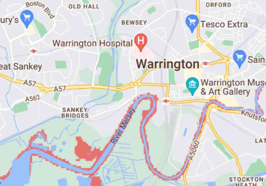
The map generated by Climate Central highlights several areas in Warrington that are particularly susceptible to flooding if sea levels continue to rise at the current rate. Among these areas are Howley, Stockton Heath, Latchford, Sankey Bridges, and Penketh, where residents may face the imminent threat of inundation. The potential impact of flooding in these regions could be devastating, with homes, businesses, and critical infrastructure at risk of being submerged under water.
In addition to these central areas of Warrington, neighboring regions such as Moore and Sandymoor, which extend into the Halton border, are also under threat. The ripple effect of rising sea levels could extend to other nearby towns like Widnes and Runcorn, encompassing areas such as Wigg Island and West Bank in its reach. The interconnected nature of these communities means that the consequences of flooding in one area could have far-reaching implications for the entire region.
As the clock ticks closer to the fateful year of 2030, it becomes increasingly urgent for local authorities and residents in Warrington to take proactive measures to mitigate the risks posed by flooding. By raising awareness, implementing effective flood defense strategies, and investing in resilient infrastructure, the town can better prepare itself for the challenges that lie ahead. Collaboration between government agencies, community organizations, and individual citizens will be crucial in ensuring the long-term sustainability and safety of Warrington in the face of climate change.
The predictions outlined in the Climate Central maps serve as a wake-up call for Warrington and other vulnerable regions around the world. Climate change is no longer a distant threat but a harsh reality that demands immediate action. By heeding the warnings of scientists and experts, we can work together to build a more resilient future for ourselves and generations to come. Let us not wait until it’s too late to address the pressing issue of flooding and its impact on our communities. The time to act is now.


 Earnings Report Sparks Analyst Upgrades")


